
Thank you for supporting this site ❤️
Make a donation
Make a donation
Gear up for your next adventure:
As an Amazon Associate, this site earns from qualifying purchases at no extra cost to you.
Lakhdaria topographic map
Click on the map to display elevation.
Thank you for supporting this site ❤️
Make a donation
Make a donation
Gear up for your next adventure:
As an Amazon Associate, this site earns from qualifying purchases at no extra cost to you.
About this map
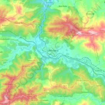
Name: Lakhdaria topographic map, elevation, terrain.
Location: Lakhdaria, Lakhdaria District, Bouira, 10002, Algeria (36.51778 3.49349 36.60512 3.68144)
Average elevation: 385 m
Minimum elevation: 61 m
Maximum elevation: 1,004 m
Thank you for supporting this site ❤️
Make a donation
Make a donation
Gear up for your next adventure:
As an Amazon Associate, this site earns from qualifying purchases at no extra cost to you.