Geolocate

Chardon topographic map

Click on the map to display elevation.

About this map

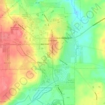
Name: Chardon topographic map, elevation, terrain.

Location: Chardon, Geauga County, Ohio, 44024, United States (41.55507 -81.24265 41.59965 -81.18749)

Average elevation: 371 m

Minimum elevation: 331 m

Maximum elevation: 414 m

Other topographic maps

Click on a map to view its topography, its elevation and its terrain.

Huntsburg

United States > Ohio > Geauga County

Average elevation: 361 m

Thompson

United States > Ohio > Geauga County

Average elevation: 359 m

Lake Aquilla

United States > Ohio > Geauga County

Average elevation: 368 m

Parkman

United States > Ohio > Geauga County > Parkman

Average elevation: 340 m

Gear up for your next adventure:

🥾Lightweight Hiking Shoes - Comfortable shoes for day hikes
🕶️Polarized Sunglasses - Protect your eyes with durable polarized lenses
Bushcraft Tarp - Versatile emergency shelter or gear protection
🧭GPS Handheld Device - Reliable GPS navigation for outdoor adventures
🚲MTB Frame Bag - Carry tools and maps directly on your bicycle frame

As an Amazon Associate, this site earns from qualifying purchases at no extra cost to you.