Geolocate

Chumukedima topographic map

Click on the map to display elevation.

About this map

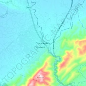
Name: Chumukedima topographic map, elevation, terrain.

Location: Chumukedima, Chümoukedima, Nagaland, 797103, India (25.76903 93.74812 25.84903 93.82812)

Average elevation: 251 m

Minimum elevation: 160 m

Maximum elevation: 736 m

Other topographic maps

Click on a map to view its topography, its elevation and its terrain.

Agri Expo

India > Nagaland > Chumukedima

Average elevation: 169 m

Rangapahar WLS

India > Nagaland > Chumukedima

Average elevation: 159 m

Gear up for your next adventure:

🛏️Sleeping Bag - Warm and compact sleeping bags for outdoor camping
🧰Survival Kit - Essential gear for emergencies in the wilderness
🥾Mountaineering Boots - Supportive boots for climbing and high-altitude hiking
🧴Outdoor Sunscreen - High SPF protection for high-altitude UV exposure
🗺️Topographic Maps - Detailed maps to explore trails, mountains, and wilderness areas

As an Amazon Associate, this site earns from qualifying purchases at no extra cost to you.