
Thank you for supporting this site ❤️
Make a donation
Make a donation
Gear up for your next adventure:
As an Amazon Associate, this site earns from qualifying purchases at no extra cost to you.
Pasrujambe topographic map
Click on the map to display elevation.
Thank you for supporting this site ❤️
Make a donation
Make a donation
Gear up for your next adventure:
As an Amazon Associate, this site earns from qualifying purchases at no extra cost to you.
About this map
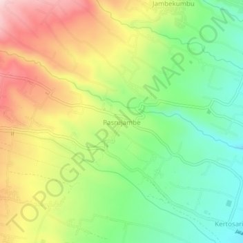
Name: Pasrujambe topographic map, elevation, terrain.
Location: Pasrujambe, Lumajang, East Java, Java, 67361, Indonesia (-8.13962 113.03866 -8.09962 113.07866)
Average elevation: 517 m
Minimum elevation: 376 m
Maximum elevation: 698 m
Thank you for supporting this site ❤️
Make a donation
Make a donation
Gear up for your next adventure:
As an Amazon Associate, this site earns from qualifying purchases at no extra cost to you.