Geolocate

Inzell topographic map

Click on the map to display elevation.

About this map

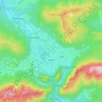
Name: Inzell topographic map, elevation, terrain.

Location: Inzell, Landkreis Traunstein, Bavaria, 83334, Germany (47.73287 12.71059 47.81037 12.84862)

Average elevation: 929 m

Minimum elevation: 619 m

Maximum elevation: 1,755 m

Gear up for your next adventure:

🥾Trail Hiking Shoes - Durable shoes designed for rugged trails
💡LED Headlamp - Hands-free illumination for night hiking and camping
💡LED Camping Lantern - Illuminate your campsite with long-lasting lanterns
🥾Waterproof Hiking Boots - Boots keeping your feet dry in wet conditions
🔥Emergency Fire Starter - Reliable ignition source for all weather conditions

As an Amazon Associate, this site earns from qualifying purchases at no extra cost to you.