
Thank you for supporting this site ❤️
Make a donation
Make a donation
Gear up for your next adventure:
As an Amazon Associate, this site earns from qualifying purchases at no extra cost to you.
İçören topographic map
Click on the map to display elevation.
Thank you for supporting this site ❤️
Make a donation
Make a donation
Gear up for your next adventure:
As an Amazon Associate, this site earns from qualifying purchases at no extra cost to you.
About this map
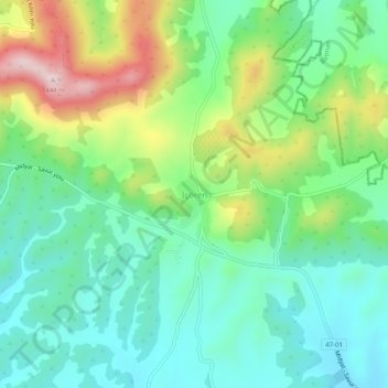
Name: İçören topographic map, elevation, terrain.
Location: İçören, Savur, Mardin, Southeastern Anatolia Region, Turkey (37.53811 41.07543 37.57811 41.11543)
Average elevation: 1,198 m
Minimum elevation: 1,081 m
Maximum elevation: 1,453 m
Thank you for supporting this site ❤️
Make a donation
Make a donation
Gear up for your next adventure:
As an Amazon Associate, this site earns from qualifying purchases at no extra cost to you.