
Make a donation
Gear up for your next adventure:
As an Amazon Associate, this site earns from qualifying purchases at no extra cost to you.
Municipio Sucre topographic map
Click on the map to display elevation.
Make a donation
Gear up for your next adventure:
As an Amazon Associate, this site earns from qualifying purchases at no extra cost to you.
About this map
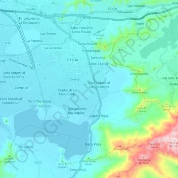
Name: Municipio Sucre topographic map, elevation, terrain.
Location: Municipio Sucre, Aragua, Central, 2122, Venezuela (10.11341 -67.50567 10.20705 -67.38614)
Average elevation: 531 m
Minimum elevation: 431 m
Maximum elevation: 1,125 m
Make a donation
Gear up for your next adventure:
As an Amazon Associate, this site earns from qualifying purchases at no extra cost to you.
Other topographic maps
Click on a map to view its topography, its elevation and its terrain.
El Limón
El Limón se localiza al noroeste de los fértiles Valles de Aragua, con longitud de 67°37’40’’ y latitud de 10°18’30’’ y altitud de 483 msnm. A 7 km al norte de Maracay constituye la puerta de entrada al sector oeste del parque nacional Henry Pittier y el único paso terrestre hacia el Municipio…
Average elevation: 695 m
Make a donation
Gear up for your next adventure:
As an Amazon Associate, this site earns from qualifying purchases at no extra cost to you.