
Odemira topographic map
Interactive map
Click on the map to display elevation.
About this map
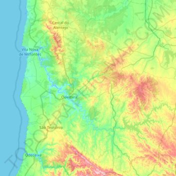
Name: Odemira topographic map, elevation, terrain.
Location: Odemira, Beja, Portugal (37.37372 -8.81953 37.87091 -8.31187)
Average elevation: 104 m
Minimum elevation: -4 m
Maximum elevation: 497 m
Other topographic maps
Click on a map to view its topography, its elevation and its terrain.
Zebro de Cima
Portugal > Beja > São Barnabé
Zebro de Cima, São Barnabé, Almodôvar, Beja, Portugal
Average elevation: 305 m
São Martinho das Amoreiras
São Martinho das Amoreiras, Odemira, Beja, Portugal
Average elevation: 206 m
Luzianes-Gare
Portugal > Beja > Luzianes-Gare > Luzianes-Gare
Luzianes-Gare, Beja, Portugal
Average elevation: 158 m
Santana da Serra
Portugal > Beja > Santana da Serra
Santana da Serra, Ourique, Beja, Portugal
Average elevation: 227 m
Region Alentejo
Portugal > Beja > Salvador e Santa Maria da Feira
Region Alentejo, Salvador e Santa Maria da Feira, Beja, 7800-561, Portugal
Average elevation: 170 m
Vila Nova de Milfontes
Vila Nova de Milfontes, Odemira, Beja, Portugal
Average elevation: 93 m