Geolocate

Oberlech topographic map

Click on the map to display elevation.

About this map

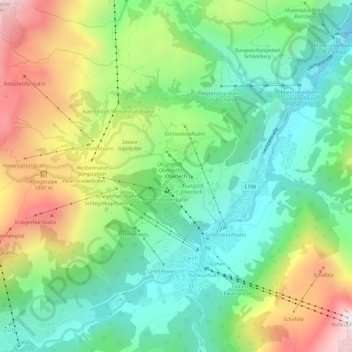
Name: Oberlech topographic map, elevation, terrain.

Location: Oberlech, Lech, Bezirk Bludenz, Vorarlberg, 6764, Austria (47.19844 10.11757 47.23844 10.15757)

Average elevation: 1,725 m

Minimum elevation: 1,378 m

Maximum elevation: 2,340 m

Gear up for your next adventure:

🩹Compact First Aid Kit - Pre-packed essentials for common trail injuries
🧥Thermal Fleece Jacket - Versatile insulation for changing mountain temperatures
🧳Compression Sacks - Maximize space in your backpack by shrinking gear
🔦LED Headlamp - Hands-free lighting for early morning starts or late finishes
👟Leg Gaiters - Keep debris, mud, and snow out of your boots

As an Amazon Associate, this site earns from qualifying purchases at no extra cost to you.