
Make a donation
Gear up for your next adventure:
As an Amazon Associate, this site earns from qualifying purchases at no extra cost to you.
Yakushima topographic map
Click on the map to display elevation.
Make a donation
Gear up for your next adventure:
As an Amazon Associate, this site earns from qualifying purchases at no extra cost to you.
Yakushima
The bedrock of the island is granite, and as such it hosts no active volcanoes. It has an area of approximately 504.5 square kilometres (194.8 sq mi). The island is roughly circular in shape, with a circumference of 89 kilometres (55 mi) and a diameter of 28 kilometres (17 mi). The highest elevations on the island are Miyanouradake (宮之浦岳), with a height of 1,935 metres (6,348 ft), and Nagatadake (永田岳), with a height of 1,886 metres (6,188 ft) above sea level; however, Yakushima has another 30 peaks of over 1,000 metres (3,300 ft) in height. There are numerous hot springs on the island.
Make a donation
Gear up for your next adventure:
As an Amazon Associate, this site earns from qualifying purchases at no extra cost to you.
About this map
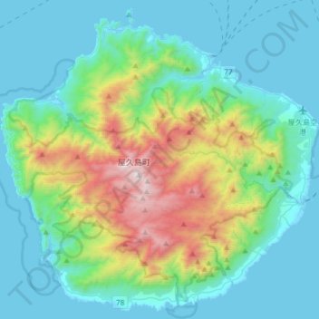
Name: Yakushima topographic map, elevation, terrain.
Location: Yakushima, Kumage County, Kagoshima Prefecture, Japan (30.22634 130.37636 30.46950 130.67177)
Average elevation: 401 m
Minimum elevation: -2 m
Maximum elevation: 1,904 m
Make a donation
Gear up for your next adventure:
As an Amazon Associate, this site earns from qualifying purchases at no extra cost to you.