
Thank you for supporting this site ❤️
Make a donation
Make a donation
Gear up for your next adventure:
As an Amazon Associate, this site earns from qualifying purchases at no extra cost to you.
Piloni topographic map
Click on the map to display elevation.
Thank you for supporting this site ❤️
Make a donation
Make a donation
Gear up for your next adventure:
As an Amazon Associate, this site earns from qualifying purchases at no extra cost to you.
About this map
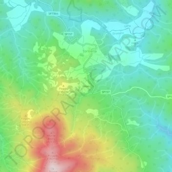
Name: Piloni topographic map, elevation, terrain.
Location: Piloni, Torniella, Roccastrada, Grosseto, Toscana, Italia (43.04626 11.13215 43.08626 11.17215)
Average elevation: 434 m
Minimum elevation: 274 m
Maximum elevation: 785 m
Thank you for supporting this site ❤️
Make a donation
Make a donation
Gear up for your next adventure:
As an Amazon Associate, this site earns from qualifying purchases at no extra cost to you.