
Easter Island topographic map
Click on the map to display elevation.
About this map
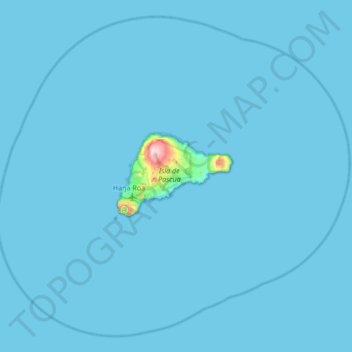
Name: Easter Island topographic map, elevation, terrain.
Location: Easter Island, Valparaiso Region, 2770000, Chile (-27.40200 -109.67958 -26.85500 -109.00299)
Average elevation: 5 m
Minimum elevation: 0 m
Maximum elevation: 501 m
Other topographic maps
Click on a map to view its topography, its elevation and its terrain.
Bellavista
Chile > Valparaiso Region > Provincia de San Felipe de Aconcagua > San Felipe
Average elevation: 637 m