Geolocate

Maglie topographic map

Click on the map to display elevation.

About this map

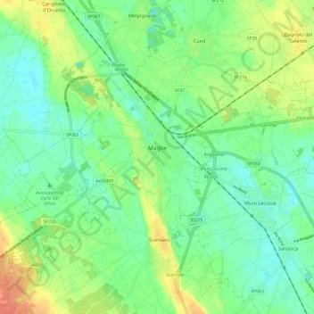
Name: Maglie topographic map, elevation, terrain.

Location: Maglie, Lecce, Apulia, 73024, Italy (40.08585 18.23658 40.14560 18.35624)

Average elevation: 87 m

Minimum elevation: 72 m

Maximum elevation: 113 m

Other topographic maps

Click on a map to view its topography, its elevation and its terrain.

Porto Miggiano

Italy > Apulia > Lecce > Santa Cesarea Terme

Average elevation: 48 m

Torre Rinalda

Italy > Apulia > Lecce > Lecce

Average elevation: 1 m

Santa Maria di Leuca

Italy > Apulia > Lecce

Average elevation: 41 m

Giorgilorio

Italy > Apulia > Lecce > Surbo > Giorgilorio

Average elevation: 43 m

Porto Badisco

Italy > Apulia > Lecce > Otranto

Average elevation: 38 m

Gear up for your next adventure:

👖Convertible Hiking Pants - Zip-off legs to adapt to changing weather conditions
🧭GPS Tracker - Track your location in remote areas safely
💡Solar Camping Lamp - Eco-friendly lighting for campsites
🥾Trekking Poles - Adjustable trekking poles to reduce knee stress and improve stability
🪜Heavy Duty Carabiners - Multi-use clips for securing gear to your backpack

As an Amazon Associate, this site earns from qualifying purchases at no extra cost to you.