
Make a donation
Gear up for your next adventure:
As an Amazon Associate, this site earns from qualifying purchases at no extra cost to you.
Chestnut Ridge Heritage Preserve topographic map
Click on the map to display elevation.
Make a donation
Gear up for your next adventure:
As an Amazon Associate, this site earns from qualifying purchases at no extra cost to you.
About this map
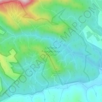
Name: Chestnut Ridge Heritage Preserve topographic map, elevation, terrain.
Average elevation: 391 m
Minimum elevation: 290 m
Maximum elevation: 727 m
Make a donation
Gear up for your next adventure:
As an Amazon Associate, this site earns from qualifying purchases at no extra cost to you.
Other topographic maps
Click on a map to view its topography, its elevation and its terrain.
Georgia Street Park
United States > South Carolina > Greenville County > Fountain Inn
Average elevation: 257 m
Make a donation
Gear up for your next adventure:
As an Amazon Associate, this site earns from qualifying purchases at no extra cost to you.
Hampton Forest Apartments
United States > South Carolina > Greenville County > Wade Hampton
Average elevation: 306 m
Make a donation
Gear up for your next adventure:
As an Amazon Associate, this site earns from qualifying purchases at no extra cost to you.
Morningside
United States > South Carolina > Greenville County > Wade Hampton
Average elevation: 300 m
Make a donation
Gear up for your next adventure:
As an Amazon Associate, this site earns from qualifying purchases at no extra cost to you.
Make a donation
Gear up for your next adventure:
As an Amazon Associate, this site earns from qualifying purchases at no extra cost to you.
Marshall Forest
United States > South Carolina > Greenville County > Greenville
Average elevation: 278 m
Make a donation
Gear up for your next adventure:
As an Amazon Associate, this site earns from qualifying purchases at no extra cost to you.
Kendall Green
United States > South Carolina > Greenville County > Greenville
Average elevation: 298 m
Make a donation
Gear up for your next adventure:
As an Amazon Associate, this site earns from qualifying purchases at no extra cost to you.
Make a donation
Gear up for your next adventure:
As an Amazon Associate, this site earns from qualifying purchases at no extra cost to you.
Make a donation
Gear up for your next adventure:
As an Amazon Associate, this site earns from qualifying purchases at no extra cost to you.
Make a donation
Gear up for your next adventure:
As an Amazon Associate, this site earns from qualifying purchases at no extra cost to you.
Powderhorn
United States > South Carolina > Greenville County > Simpsonville > Powderhorn
Average elevation: 259 m
Make a donation
Gear up for your next adventure:
As an Amazon Associate, this site earns from qualifying purchases at no extra cost to you.
Mountain View Homes
United States > South Carolina > Greenville County > Greenville
Average elevation: 299 m
The Vintage Apartment Homes
United States > South Carolina > Greenville County > Greenville
Average elevation: 305 m