
Make a donation
Gear up for your next adventure:
As an Amazon Associate, this site earns from qualifying purchases at no extra cost to you.
Kreuzspitz topographic map
Click on the map to display elevation.
Make a donation
Gear up for your next adventure:
As an Amazon Associate, this site earns from qualifying purchases at no extra cost to you.
About this map
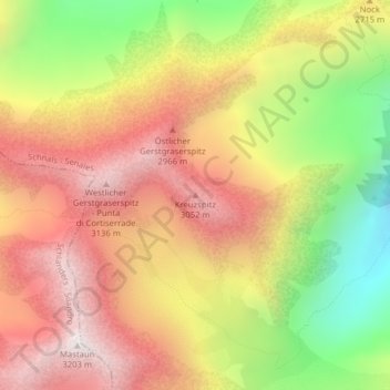
Name: Kreuzspitz topographic map, elevation, terrain.
Average elevation: 2,665 m
Minimum elevation: 2,024 m
Maximum elevation: 3,177 m
Make a donation
Gear up for your next adventure:
As an Amazon Associate, this site earns from qualifying purchases at no extra cost to you.
Other topographic maps
Click on a map to view its topography, its elevation and its terrain.
Schnalstal
Italien > Trentino-Südtirol > Bozen > Schnals
Auf der orographisch linken Seite befindet sich das Pfossental, das mit Abstand längste Schnalser Seitental. Dieses zweigt zwischen Katharinaberg und Karthaus ab und führt zwischen Texelgruppe und Schnalskamm zunächst nordwärts, später ostwärts, ehe es unter dem Eisjöchl endet, einem 2895 m hohen…
Average elevation: 2,193 m