Geolocate

Cutler topographic map

Click on the map to display elevation.

About this map

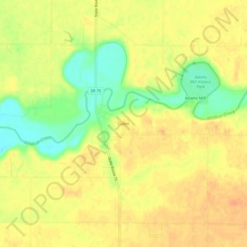
Name: Cutler topographic map, elevation, terrain.

Location: Cutler, Carroll County, Indiana, 46920, United States (40.45642 -86.54416 40.49642 -86.50416)

Average elevation: 223 m

Minimum elevation: 199 m

Maximum elevation: 235 m

Other topographic maps

Click on a map to view its topography, its elevation and its terrain.

Delphi

United States > Indiana > Carroll County

Average elevation: 179 m

Delphi

United States > Indiana > Carroll County

Average elevation: 179 m

Gear up for your next adventure:

🥾Approach Shoes - Shoes designed for climbing approaches and rugged trails
💧Reusable Water Bottle - Durable water bottles for hydration on trails
💡LED Headlamp - Hands-free illumination for night hiking and camping
🧥Thermal Layer - Insulating layer for cold outdoor conditions
🔦LED Flashlight - Powerful and long-lasting flashlight for camping and emergencies

As an Amazon Associate, this site earns from qualifying purchases at no extra cost to you.