Geolocate

White Bird topographic map

Click on the map to display elevation.

About this map

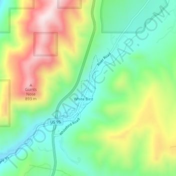
Name: White Bird topographic map, elevation, terrain.

Location: White Bird, Idaho County, Idaho, United States (45.75840 -116.30541 45.76871 -116.29720)

Average elevation: 637 m

Minimum elevation: 451 m

Maximum elevation: 936 m

Other topographic maps

Click on a map to view its topography, its elevation and its terrain.

High Camp

United States > Idaho > Idaho County

Average elevation: 1,666 m

Big Mallard Creek

United States > Idaho > Idaho County

Average elevation: 1,718 m

Bat Point

United States > Idaho > Idaho County

Average elevation: 1,649 m

Pollock

United States > Idaho > Idaho County

Average elevation: 913 m

Dixie

United States > Idaho > Idaho County

Average elevation: 1,781 m

Nugget Point

United States > Idaho > Idaho County

Average elevation: 1,659 m

The Maze

United States > Idaho > Idaho County

Average elevation: 533 m

Royal Gorge

United States > Idaho > Idaho County

Average elevation: 681 m

Dry Can Creek

United States > Idaho > Idaho County

Average elevation: 1,163 m

Gear up for your next adventure:

🕶️Polarized Sunglasses - Reduces glare from snow and water at high elevations
🛁Quick-Dry Microfiber Towel - Space-saving towel that dries rapidly on the move
🧥Ultralight Puffy Jacket - Maximum warmth that packs down to the size of an orange
🧴Insect Repellent - Protect yourself from bugs during outdoor adventures
Tent Footprint - Protect tent floor and increase durability

As an Amazon Associate, this site earns from qualifying purchases at no extra cost to you.