Geolocate

Dadapsari topographic map

Click on the map to display elevation.

About this map

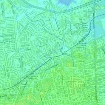
Name: Dadapsari topographic map, elevation, terrain.

Location: Dadapsari, Semarang Utara, Semarang, Central Java, Indonesia (-6.97068 110.41541 -6.96423 110.42501)

Average elevation: 6 m

Minimum elevation: 0 m

Maximum elevation: 11 m

Other topographic maps

Click on a map to view its topography, its elevation and its terrain.

Ngaliyan

Indonesia > Central Java > Semarang

Average elevation: 125 m

Tembalang

Indonesia > Central Java > Semarang > Bulusan

Average elevation: 194 m

Tambakaji

Indonesia > Central Java > Semarang

Average elevation: 60 m

Gunungpati

Indonesia > Central Java > Semarang

Average elevation: 303 m

Tikung

Indonesia > Central Java > Semarang

Average elevation: 22 m

Kramas

Indonesia > Central Java > Semarang

Average elevation: 170 m

Candisari

Indonesia > Central Java > Semarang

Average elevation: 126 m

Gajahmungkur

Indonesia > Central Java > Semarang

Average elevation: 64 m

Ampelgading

Indonesia > Central Java > Semarang

Average elevation: 196 m

Gear up for your next adventure:

🧦Crew Hiking Socks - Comfortable socks for long-distance hikes
💧Collapsible Water Bottle - Space-saving water bottle for outdoor activities
🐕Hiking Dog Pack - Let your canine companion carry their own water and food
Lightweight Backpacking Tent - Compact tent for efficient hiking trips
🔪Outdoor Multitool - Versatile tool for repairs and food prep in the wild

As an Amazon Associate, this site earns from qualifying purchases at no extra cost to you.