
Make a donation
Gear up for your next adventure:
As an Amazon Associate, this site earns from qualifying purchases at no extra cost to you.
Illmensee topographic map
Click on the map to display elevation.
Make a donation
Gear up for your next adventure:
As an Amazon Associate, this site earns from qualifying purchases at no extra cost to you.
Illmensee
The municipality (Gemeinde) of Illmensee is situated at the southeastern corner of the district of Sigmaringen, in the German state of Baden-Württemberg. Illmensee lies along Sigmaringen's border with the district of Ravensburg to the east and the Bodensee district to the south. The municipality is physically located in a depression formed by the Würm glaciation in the Upper Swabian hill country [de]. The municipality's three lakes, the Illmensee itself, Ruschweiler [de], and the Volzer [de] lakes, are glacial lakes that were also formed by the Würm glaciation. Elevation above sea level in the municipal area ranges from a high of 833 meters (2,733 ft) Normalnull (NN) to a low of 667 meters (2,188 ft) NN.
Make a donation
Gear up for your next adventure:
As an Amazon Associate, this site earns from qualifying purchases at no extra cost to you.
About this map
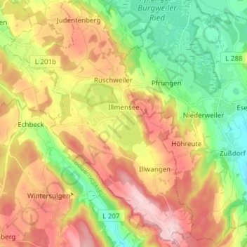
Name: Illmensee topographic map, elevation, terrain.
Average elevation: 698 m
Minimum elevation: 577 m
Maximum elevation: 839 m
Make a donation
Gear up for your next adventure:
As an Amazon Associate, this site earns from qualifying purchases at no extra cost to you.
Other topographic maps
Click on a map to view its topography, its elevation and its terrain.
Steinbronnen
Germany > Baden-Württemberg > Landkreis Sigmaringen > Bad Saulgau > Bierstetten
Average elevation: 638 m
Make a donation
Gear up for your next adventure:
As an Amazon Associate, this site earns from qualifying purchases at no extra cost to you.