Geolocate

Estrella topographic map

Click on the map to display elevation.

About this map

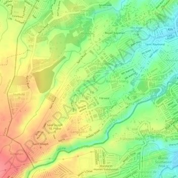
Name: Estrella topographic map, elevation, terrain.

Location: Estrella, San Pedro, Laguna, Calabarzon, 4023, Philippines (14.32957 121.01268 14.33718 121.02335)

Average elevation: 85 m

Minimum elevation: 42 m

Maximum elevation: 123 m

Other topographic maps

Click on a map to view its topography, its elevation and its terrain.

San Antonio Zone 3

Philippines > Laguna > San Pedro

Average elevation: 77 m

San Antonio East

Philippines > Laguna > San Pedro

Average elevation: 39 m

Sitio Maharlika

Philippines > Laguna > San Pedro

Average elevation: 27 m

Gear up for your next adventure:

💧Reusable Water Bottle - Durable water bottles for hydration on trails
Family Camping Tent - Spacious tent suitable for family camping trips
🧤Thermal Hiking Gloves - Grip-enhanced gloves for cold-weather altitude trekking
🧢Beanie Hat - Keep your head warm in cold weather
🏃Hydration Running Vest - Carry water and maps close to your body for speed

As an Amazon Associate, this site earns from qualifying purchases at no extra cost to you.