
Thank you for supporting this site ❤️
Make a donation
Make a donation
Gear up for your next adventure:
As an Amazon Associate, this site earns from qualifying purchases at no extra cost to you.
Lakeville topographic map
Click on the map to display elevation.
Thank you for supporting this site ❤️
Make a donation
Make a donation
Gear up for your next adventure:
As an Amazon Associate, this site earns from qualifying purchases at no extra cost to you.
About this map
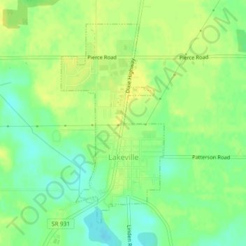
Name: Lakeville topographic map, elevation, terrain.
Location: Lakeville, Saint Joseph County, Indiana, United States (41.51729 -86.28249 41.53909 -86.26737)
Average elevation: 258 m
Minimum elevation: 246 m
Maximum elevation: 266 m
Thank you for supporting this site ❤️
Make a donation
Make a donation
Gear up for your next adventure:
As an Amazon Associate, this site earns from qualifying purchases at no extra cost to you.
Other topographic maps
Click on a map to view its topography, its elevation and its terrain.
Mishawaka
United States > Indiana > Saint Joseph County > Mishawaka > Mishawaka
Average elevation: 235 m