
Make a donation
Gear up for your next adventure:
As an Amazon Associate, this site earns from qualifying purchases at no extra cost to you.
Udaipur topographic map
Click on the map to display elevation.
Make a donation
Gear up for your next adventure:
As an Amazon Associate, this site earns from qualifying purchases at no extra cost to you.
Udaipur
Udaipur is located at 23°32′N 91°29′E / 23.53°N 91.48°E / 23.53; 91.48. It has an average elevation of 22 meters (72 feet)from the sea level. The Gomati river passes through the heart of Udaipur and helps in irrigation of its lands.
Make a donation
Gear up for your next adventure:
As an Amazon Associate, this site earns from qualifying purchases at no extra cost to you.
About this map
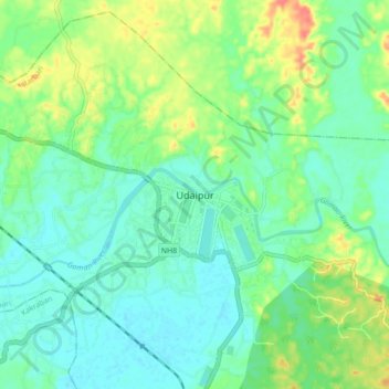
Name: Udaipur topographic map, elevation, terrain.
Location: Udaipur, Matarbari, Udaipur, Gomati, Tripura, 799120, India (23.50162 91.45176 23.58162 91.53176)
Average elevation: 33 m
Minimum elevation: 16 m
Maximum elevation: 70 m
Make a donation
Gear up for your next adventure:
As an Amazon Associate, this site earns from qualifying purchases at no extra cost to you.