Geolocate

Teis topographic map

Click on the map to display elevation.

About this map

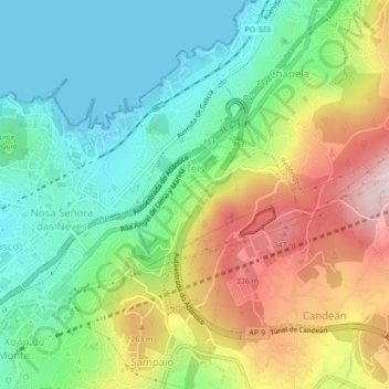
Name: Teis topographic map, elevation, terrain.

Location: Teis, Vigo, Pontevedra, Galicia, Spain (42.23869 -8.71141 42.26470 -8.66713)

Average elevation: 88 m

Minimum elevation: -1 m

Maximum elevation: 335 m

Other topographic maps

Click on a map to view its topography, its elevation and its terrain.

Redondela

Spain > Galicia > Vigo > Redondela

Average elevation: 188 m

Gear up for your next adventure:

🔭Compact Monocular - One-handed bird watching and trail spotting
🔦LED Flashlight - Powerful and long-lasting flashlight for camping and emergencies
🧥Thermal Fleece Jacket - Versatile insulation for changing mountain temperatures
👖Convertible Hiking Pants - Zip-off legs to adapt to changing weather conditions
🧴First Aid Kit - Essential first aid supplies for outdoor emergencies

As an Amazon Associate, this site earns from qualifying purchases at no extra cost to you.