Geolocate

Ghansali topographic map

Click on the map to display elevation.

About this map

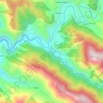
Name: Ghansali topographic map, elevation, terrain.

Location: Ghansali, Tehri Garhwal, Uttarakhand, India (30.40526 78.64486 30.44526 78.68486)

Average elevation: 1,111 m

Minimum elevation: 824 m

Maximum elevation: 1,534 m

Gear up for your next adventure:

🧦Thermal Socks - Warm socks for winter hiking or camping
🦯Trekking Poles - Reduced impact on joints for steep topographic climbs
🥾Mountaineering Boots - Supportive boots for climbing and high-altitude hiking
🧢Sun Hat - Wide-brim hat for sun protection
🥘Camping Cookware Set - Compact nesting pots and pans for trail cooking

As an Amazon Associate, this site earns from qualifying purchases at no extra cost to you.