
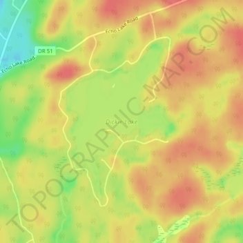
Dickie Lake topographic map
Interactive map
Click on the map to display elevation.
About this map
Name: Dickie Lake topographic map, elevation, terrain.
Average elevation: 360 m
Minimum elevation: 320 m
Maximum elevation: 383 m
Other topographic maps
Click on a map to view its topography, its elevation and its terrain.
Ril Lake
Canada > Ontario > Lake of Bays Township > Lake of Bays
Ril Lake, South Ril Lake Road, Lake of Bays Township, District Municipality of Muskoka, Muskoka District, Central Ontario, Ontario, Canada
Average elevation: 361 m
Grant Lake
Canada > Ontario > Lake of Bays
Grant Lake, Shoe Lake Road, Lake of Bays, District Municipality of Muskoka, Muskoka District, Ontario, P0A 1E0, Canada
Average elevation: 384 m
Cream Lake
Canada > Ontario > Lake of Bays
Cream Lake, South Ril Lake Road, Lake of Bays, District Municipality of Muskoka, Muskoka District, Ontario, Canada
Average elevation: 363 m
Menominee Lake
Canada > Ontario > Lake of Bays
Menominee Lake, Grand Boulevard, Lake of Bays, District Municipality of Muskoka, Muskoka District, Ontario, Canada
Average elevation: 355 m
Dotty Lake
Canada > Ontario > Lake of Bays
Dotty Lake, Brookes Road, Lake of Bays, District Municipality of Muskoka, Muskoka District, Ontario, Canada
Average elevation: 403 m
Porcupine Lake
Canada > Ontario > Lake of Bays
Porcupine Lake, South Ril Lake Road, Lake of Bays, District Municipality of Muskoka, Muskoka District, Ontario, Canada
Average elevation: 361 m