
Besozzo topographic map
Click on the map to display elevation.
About this map
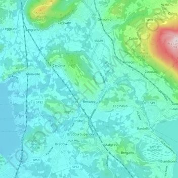
Name: Besozzo topographic map, elevation, terrain.
Location: Besozzo, Varese, Lombardy, 21023, Italy (45.83337 8.59462 45.86841 8.69833)
Average elevation: 274 m
Minimum elevation: 187 m
Maximum elevation: 768 m
Other topographic maps
Click on a map to view its topography, its elevation and its terrain.
Pianca
Italy > Lombardy > Varese > Maccagno con Pino e Veddasca > Maccagno Superiore
Average elevation: 364 m
Pianca
Italy > Lombardy > Varese > Maccagno con Pino e Veddasca > Maccagno Superiore
Average elevation: 364 m
Parco archeologico di Castel Seprio
Italy > Lombardy > Varese > Castelseprio > Vico Seprio
Average elevation: 314 m