
Make a donation
Gear up for your next adventure:
As an Amazon Associate, this site earns from qualifying purchases at no extra cost to you.
Kandel topographic map
Click on the map to display elevation.
Make a donation
Gear up for your next adventure:
As an Amazon Associate, this site earns from qualifying purchases at no extra cost to you.
Kandel
Der Kandel ist mit 1241,3 m ü. NHN die höchste Erhebung im Mittleren Schwarzwald und der Hausberg der Stadt Waldkirch. Durch seine exponierte Lage wirkt er eindrucksvoller als benachbarte Berge vergleichbarer Höhe.
Make a donation
Gear up for your next adventure:
As an Amazon Associate, this site earns from qualifying purchases at no extra cost to you.
About this map
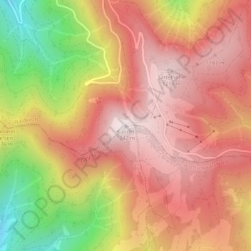
Name: Kandel topographic map, elevation, terrain.
Average elevation: 985 m
Minimum elevation: 568 m
Maximum elevation: 1,237 m
Make a donation
Gear up for your next adventure:
As an Amazon Associate, this site earns from qualifying purchases at no extra cost to you.
Other topographic maps
Click on a map to view its topography, its elevation and its terrain.
Siensbach
Deutschland > Baden-Württemberg > Landkreis Emmendingen > Waldkirch
Average elevation: 543 m
Suggental
Deutschland > Baden-Württemberg > Landkreis Emmendingen > Waldkirch
Average elevation: 336 m
Make a donation
Gear up for your next adventure:
As an Amazon Associate, this site earns from qualifying purchases at no extra cost to you.