
Shirley topographic map
Click on the map to display elevation.
About this map
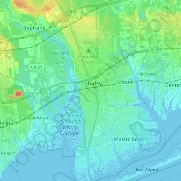
Name: Shirley topographic map, elevation, terrain.
Average elevation: 11 m
Minimum elevation: -4 m
Maximum elevation: 64 m
Other topographic maps
Click on a map to view its topography, its elevation and its terrain.
Cherry Grove
United States > New York > Suffolk County > Town of Brookhaven > Fire Island Pines
Average elevation: 0 m
Eastport South Manor Athletic Complex
United States > New York > Suffolk County > Town of Brookhaven > Eastport
Average elevation: 15 m