
Make a donation
Gear up for your next adventure:
As an Amazon Associate, this site earns from qualifying purchases at no extra cost to you.
Wilzenberg topographic map
Click on the map to display elevation.
Make a donation
Gear up for your next adventure:
As an Amazon Associate, this site earns from qualifying purchases at no extra cost to you.
Wilzenberg
Topographischen Karten ist wenige Meter südlich der Kapelle eine 635,1 m hohe Stelle zu entnehmen.
Make a donation
Gear up for your next adventure:
As an Amazon Associate, this site earns from qualifying purchases at no extra cost to you.
About this map
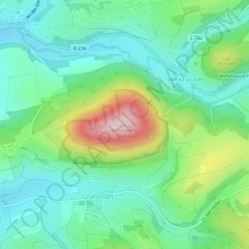
Name: Wilzenberg topographic map, elevation, terrain.
Average elevation: 463 m
Minimum elevation: 387 m
Maximum elevation: 648 m
Make a donation
Gear up for your next adventure:
As an Amazon Associate, this site earns from qualifying purchases at no extra cost to you.
Other topographic maps
Click on a map to view its topography, its elevation and its terrain.
Esenbeck
Deutschland > Nordrhein-Westfalen > Hochsauerlandkreis > Schmallenberg > Obersorpe
Average elevation: 687 m