
Make a donation
Gear up for your next adventure:
As an Amazon Associate, this site earns from qualifying purchases at no extra cost to you.
La Enea topographic map
Click on the map to display elevation.
Make a donation
Gear up for your next adventure:
As an Amazon Associate, this site earns from qualifying purchases at no extra cost to you.
About this map
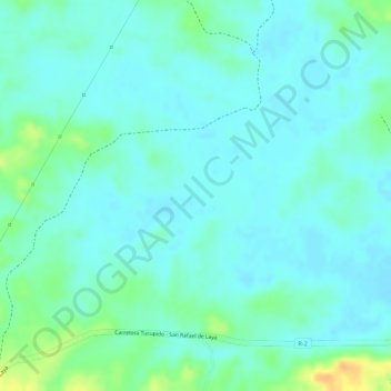
Name: La Enea topographic map, elevation, terrain.
Average elevation: 88 m
Minimum elevation: 78 m
Maximum elevation: 115 m
Make a donation
Gear up for your next adventure:
As an Amazon Associate, this site earns from qualifying purchases at no extra cost to you.
Other topographic maps
Click on a map to view its topography, its elevation and its terrain.
Tucupido
Venezuela > Estado Guárico > Municipio Ribas
Tucupido es una población venezolana, capital del Municipio José Félix Ribas del Estado Guárico en Los Llanos, se estima que cuenta con una población de más de 55.000 habitantes. Ocupa la divisoria de aguas entre el río Tamanaco y la quebrada Jabillal. El río Tucupido afluye al Tamanaco al noreste de…
Average elevation: 117 m