Geolocate

Bidhannagar topographic map

Click on the map to display elevation.

Bidhannagar

Salt Lake is located at 22°35′N 88°25′E / 22.58°N 88.42°E / 22.58; 88.42. It has an average elevation of 11 metres (49 ft).

Wikipedia (CC-BY-SA 3.0)

About this map

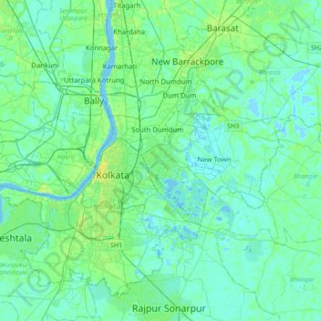
Name: Bidhannagar topographic map, elevation, terrain.

Location: Bidhannagar, Bhangar - II, South 24 Parganas, West Bengal, 700064, India (22.42688 88.25561 22.74688 88.57561)

Average elevation: 5 m

Minimum elevation: -2 m

Maximum elevation: 23 m

Other topographic maps

Click on a map to view its topography, its elevation and its terrain.

Kestopur Khal

India > West Bengal > Bhangar - II > Bidhannagar

Average elevation: 4 m

Gear up for your next adventure:

🛏️Sleeping Bag - Warm and compact sleeping bags for outdoor camping
🚲MTB Frame Bag - Carry tools and maps directly on your bicycle frame
🛶Canoe Life Vest - Safety vest for water sports
🥾Lightweight Hiking Boots - Boots for comfort and mobility on long hikes
🧊Portable Cooler - Keep food and drinks cold during outdoor adventures

As an Amazon Associate, this site earns from qualifying purchases at no extra cost to you.