
Make a donation
Gear up for your next adventure:
As an Amazon Associate, this site earns from qualifying purchases at no extra cost to you.
Herweg topographic map
Click on the map to display elevation.
Make a donation
Gear up for your next adventure:
As an Amazon Associate, this site earns from qualifying purchases at no extra cost to you.
Herweg
1815/16 lebten 27 Einwohner im Ort. 1832 gehörte Kormannshausen der Herdingsfelder Honschaft an, die ein Teil der Hückeswagener Außenbürgerschaft innerhalb der Bürgermeisterei Hückeswagen war. Der laut der Statistik und Topographie des Regierungsbezirks Düsseldorf als Weiler kategorisierte Ort besaß zu dieser Zeit eine Schule (bei Neuenherweg), fünf Wohnhäuser und sieben landwirtschaftliche Gebäude. Zu dieser Zeit lebten 43 Einwohner im Ort, davon zwei katholischen und 41 evangelischen Glaubens.
Make a donation
Gear up for your next adventure:
As an Amazon Associate, this site earns from qualifying purchases at no extra cost to you.
About this map
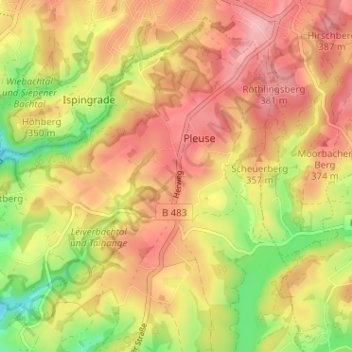
Name: Herweg topographic map, elevation, terrain.
Average elevation: 336 m
Minimum elevation: 254 m
Maximum elevation: 395 m
Make a donation
Gear up for your next adventure:
As an Amazon Associate, this site earns from qualifying purchases at no extra cost to you.