Geolocate

Revora topographic map

Click on the map to display elevation.

About this map

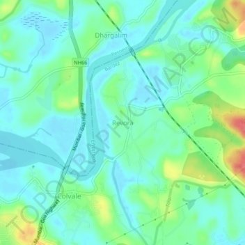
Name: Revora topographic map, elevation, terrain.

Location: Revora, Bardez, North Goa, Goa, 403513, India (15.63670 73.82647 15.67670 73.86647)

Average elevation: 18 m

Minimum elevation: -2 m

Maximum elevation: 73 m

Other topographic maps

Click on a map to view its topography, its elevation and its terrain.

Anjuna

India > Goa > Bardez > Anjuna

Average elevation: 14 m

Pilerne Lake

India > Goa > Bardez > Sangolda

Average elevation: 39 m

Corjuem Fort

India > Goa > Bardez > Corjuem

Average elevation: 13 m

Aguada Fort

India > Goa > Bardez > Sinquerim

Average elevation: 8 m

Anjuna

India > Goa > Bardez

Average elevation: 13 m

Anjuna Beach

India > Goa > Bardez > Anjuna

Average elevation: 10 m

Chapora Fort

India > Goa > Bardez > Chapora

Average elevation: 8 m

Gear up for your next adventure:

🔦LED Headlamp - Hands-free lighting for early morning starts or late finishes
🔭Outdoor Binoculars - Lightweight binoculars for birdwatching and hiking
🧥Waterproof Jacket - Lightweight rain jackets for hiking and outdoor activities
👟Leg Gaiters - Keep debris, mud, and snow out of your boots
🦯Trekking Poles - Reduced impact on joints for steep topographic climbs

As an Amazon Associate, this site earns from qualifying purchases at no extra cost to you.