Geolocate

Favone topographic map

Click on the map to display elevation.

About this map
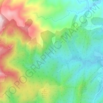
Name: Favone topographic map, elevation, terrain.

Location: Favone, Sari-Solenzara, Sartène, Corse-du-Sud, Corse, France métropolitaine, 20145, France (41.77416 9.33806 41.78701 9.39571)

Average elevation: 283 m

Minimum elevation: 0 m

Maximum elevation: 709 m

Other topographic maps

Click on a map to view its topography, its elevation and its terrain.

Punta di l'Oru

France > Corse > Corse-du-Sud > Sari-Solenzara

Average elevation: 47 m

Togna

France > Corse > Corse-du-Sud > Sari-Solenzara

Average elevation: 174 m

Solenzara

France > Corse > Corse-du-Sud > Sari-Solenzara

Average elevation: 52 m

Gear up for your next adventure:

🥤Collapsible Travel Cup - Saves space and weight in your mess kit
⛺Camping Tent - Weather-resistant tents suitable for 2 to 6 people
🧴Bear Spray Holster - Quick-access carry for essential Canadian wilderness safety
🎒Hiking Daypack - Lightweight and durable backpacks for day trips and excursions
🕯️Camping Lantern - Illuminates your entire campsite with high-efficiency LEDs

As an Amazon Associate, this site earns from qualifying purchases at no extra cost to you.