
San Andrés Cholula topographic map
Interactive map
Click on the map to display elevation.
About this map
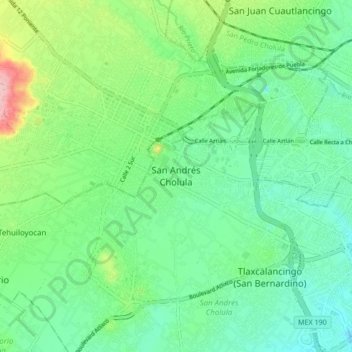
Name: San Andrés Cholula topographic map, elevation, terrain.
Location: San Andrés Cholula, Puebla, 72810, México (19.01194 -98.33762 19.09194 -98.25762)
Average elevation: 2,143 m
Minimum elevation: 2,096 m
Maximum elevation: 2,265 m
Other topographic maps
Click on a map to view its topography, its elevation and its terrain.
Tlaxcalancingo (San Bernardino)
México > Puebla > San Andrés Cholula > Tlaxcalancingo (San Bernardino)
Tlaxcalancingo (San Bernardino), San Andrés Cholula, Puebla, 72821, México
Average elevation: 2,123 m