Geolocate

Rosendale topographic map

Click on the map to display elevation.

About this map

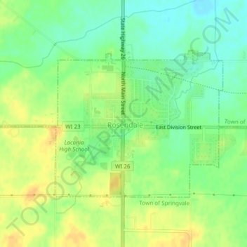
Name: Rosendale topographic map, elevation, terrain.

Location: Rosendale, Fond du Lac County, Wisconsin, United States (43.80008 -88.68539 43.81612 -88.65998)

Average elevation: 277 m

Minimum elevation: 263 m

Maximum elevation: 290 m

Other topographic maps

Click on a map to view its topography, its elevation and its terrain.

Waucousta

United States > Wisconsin > Fond du Lac County

Average elevation: 316 m

Eldorado

United States > Wisconsin > Fond du Lac County

Average elevation: 267 m

Gear up for your next adventure:

🌬️Windproof Camp Stove - Efficient cooking even on exposed mountain peaks
🚲Heavy Duty Bike Lock - Secure your bike at the trailhead or during stops
🥾Hiking Shorts - Breathable shorts suitable for summer hikes
🎒Hiking Backpack - Lightweight and ergonomic backpacks for day hikes or multi-day treks
👟Leg Gaiters - Keep debris, mud, and snow out of your boots

As an Amazon Associate, this site earns from qualifying purchases at no extra cost to you.