
Make a donation
Gear up for your next adventure:
As an Amazon Associate, this site earns from qualifying purchases at no extra cost to you.
La Tuque topographic map
Click on the map to display elevation.
Make a donation
Gear up for your next adventure:
As an Amazon Associate, this site earns from qualifying purchases at no extra cost to you.
About this map
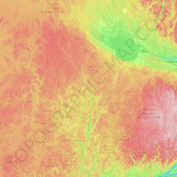
Name: La Tuque topographic map, elevation, terrain.
Average elevation: 417 m
Minimum elevation: -1 m
Maximum elevation: 1,117 m
Urban agglomeration of La Tuque trails, hiking, mountain biking, running and outdoor activities
Make a donation
Gear up for your next adventure:
As an Amazon Associate, this site earns from qualifying purchases at no extra cost to you.
Other topographic maps
Click on a map to view its topography, its elevation and its terrain.
Mont de la Tête de Brochet
Canada > Quebec > Urban agglomeration of La Tuque > La Tuque
Average elevation: 413 m
Make a donation
Gear up for your next adventure:
As an Amazon Associate, this site earns from qualifying purchases at no extra cost to you.
Lac de l'Équerre
Canada > Quebec > Urban agglomeration of La Tuque > La Tuque
Average elevation: 309 m
Lac de la Montagne Brûlée
Canada > Quebec > Urban agglomeration of La Tuque > Lac-Édouard
Average elevation: 437 m
Make a donation
Gear up for your next adventure:
As an Amazon Associate, this site earns from qualifying purchases at no extra cost to you.
Make a donation
Gear up for your next adventure:
As an Amazon Associate, this site earns from qualifying purchases at no extra cost to you.