
Make a donation
Gear up for your next adventure:
As an Amazon Associate, this site earns from qualifying purchases at no extra cost to you.
Walnut Creek topographic map
Click on the map to display elevation.
Make a donation
Gear up for your next adventure:
As an Amazon Associate, this site earns from qualifying purchases at no extra cost to you.
Walnut Creek
Walnut Creek's warm summer Mediterranean climate (Köppen climate classification Csb) is typical of California's interior valleys. In summer, high pressure results in almost unbroken sunshine and virtually no precipitation. Days start out cool but quickly warm up, with high temperatures normally in the 80s Fahrenheit (27 to 32 °C). Temperatures of 100 °F (38 °C) or hotter occur numerous times during heatwaves, however. In the winter, the jet stream moves far enough south so that Pacific storms can reach Walnut Creek, bringing much-needed rain – average annual rainfall approximates 20 inches (510 mm), with slight variations occurring in microclimates based on elevation and topography. During particularly cold storms, snow falls on the peak of nearby Mount Diablo, but snow in the valley floor is very rare. There are numerous clear, mild days in winter, often with morning frost. The climate allows for the successful cultivation of many plants and crops, being warm enough for citrus yet cold enough for apples. The Ruth Bancroft Garden is a renowned botanical garden that showcases the diversity of plants that can be successfully grown.
Make a donation
Gear up for your next adventure:
As an Amazon Associate, this site earns from qualifying purchases at no extra cost to you.
About this map
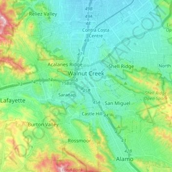
Name: Walnut Creek topographic map, elevation, terrain.
Average elevation: 119 m
Minimum elevation: 16 m
Maximum elevation: 441 m
Make a donation
Gear up for your next adventure:
As an Amazon Associate, this site earns from qualifying purchases at no extra cost to you.
Other topographic maps
Click on a map to view its topography, its elevation and its terrain.