Geolocate

Ghaniri topographic map

Click on the map to display elevation.

About this map

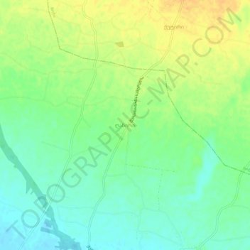
Name: Ghaniri topographic map, elevation, terrain.

Location: Ghaniri, Samtredia Municipality, Imereti, Georgia (42.22844 42.33932 42.26844 42.37932)

Average elevation: 60 m

Minimum elevation: 46 m

Maximum elevation: 76 m

Other topographic maps

Click on a map to view its topography, its elevation and its terrain.

Samtredia

Georgia > Imereti > Samtredia Municipality

Average elevation: 25 m

Samtredia

Georgia > Imereti > Samtredia Municipality

Average elevation: 26 m

Gear up for your next adventure:

🥾Waterproof Hiking Boots - Boots keeping your feet dry in wet conditions
🥫Freeze-Dried Meals - Lightweight, high-calorie nutrition for multi-day treks
🥾Trail Running Shoes - Lightweight and durable shoes for trail running
🧥Ultralight Puffy Jacket - Maximum warmth that packs down to the size of an orange
🧴Waterproofing Spray - Restore the DWR coating on jackets and tents

As an Amazon Associate, this site earns from qualifying purchases at no extra cost to you.