
Make a donation
Gear up for your next adventure:
As an Amazon Associate, this site earns from qualifying purchases at no extra cost to you.
Saint Landry topographic map
Click on the map to display elevation.
Make a donation
Gear up for your next adventure:
As an Amazon Associate, this site earns from qualifying purchases at no extra cost to you.
About this map
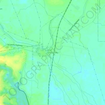
Name: Saint Landry topographic map, elevation, terrain.
Location: Saint Landry, Evangeline Parish, Louisiana, United States (30.82436 -92.27791 30.86436 -92.23791)
Average elevation: 15 m
Minimum elevation: 7 m
Maximum elevation: 29 m
Make a donation
Gear up for your next adventure:
As an Amazon Associate, this site earns from qualifying purchases at no extra cost to you.
Other topographic maps
Click on a map to view its topography, its elevation and its terrain.
Ville Platte
United States > Louisiana > Evangeline Parish
Ville Platte is the largest city in, and the parish seat of, Evangeline Parish, Louisiana, United States. The population was 6,303 at the 2020 census, down from 8,145 in 2000. The city's name is of French origin, roughly translating to "flat town", in reference to its relatively flat topography in contrast to…
Average elevation: 22 m