
Anthony Mill Dam topographic map
Interactive map
Click on the map to display elevation.
About this map
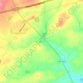
Name: Anthony Mill Dam topographic map, elevation, terrain.
Average elevation: 167 m
Minimum elevation: 122 m
Maximum elevation: 209 m
Other topographic maps
Click on a map to view its topography, its elevation and its terrain.
Strausstown
United States > Pennsylvania > Berks County > Upper Tulpehocken Township
Strausstown, Upper Tulpehocken Township, Berks County, Pennsylvania, 19559, United States
Average elevation: 176 m