Geolocate

Jainal topographic map

Click on the map to display elevation.

About this map

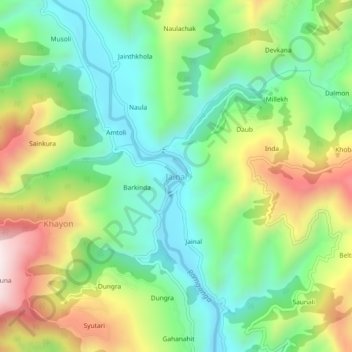
Name: Jainal topographic map, elevation, terrain.

Location: Jainal, Bhikiasain, Almora, Uttarakhand, 263667, India (29.71312 79.23537 29.75312 79.27537)

Average elevation: 1,025 m

Minimum elevation: 772 m

Maximum elevation: 1,459 m

Other topographic maps

Click on a map to view its topography, its elevation and its terrain.

Gagas

India > Uttarakhand > Bhikiasain > Bhikia Sain > Saboli Rautela

Average elevation: 908 m

Gagas

India > Uttarakhand > Bhikiasain > Bhikia Sain > Saboli Rautela

Average elevation: 908 m

Gear up for your next adventure:

🧤Thermal Hiking Gloves - Grip-enhanced gloves for cold-weather altitude trekking
👟Leg Gaiters - Keep debris, mud, and snow out of your boots
🧴Insect Repellent - Protect yourself from bugs during outdoor adventures
🥾Trail Hiking Shoes - Durable shoes designed for rugged trails
🧦Crew Hiking Socks - Comfortable socks for long-distance hikes

As an Amazon Associate, this site earns from qualifying purchases at no extra cost to you.