
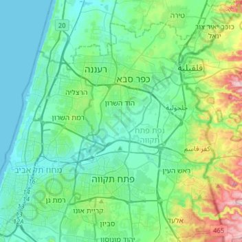
Drom HaSharon Regional Council topographic map
Interactive map
Click on the map to display elevation.
About this map
Name: Drom HaSharon Regional Council topographic map, elevation, terrain.
Average elevation: 58 m
Minimum elevation: -1 m
Maximum elevation: 284 m
Other topographic maps
Click on a map to view its topography, its elevation and its terrain.
Rishon LeZion
Rishon LeZion, Rehovot Subdistrict, Center District, Israel
Average elevation: 33 m
Hadid
Israel > Center District > Hevel Modiin Regional Council
Hadid, Hevel Modiin Regional Council, Ramla Subdistrict, Center District, Israel
Average elevation: 72 m
Hayovel
Israel > Center District > Rehovot > Hayovel
Hayovel, Rehovot, Rehovot Subdistrict, Center District, 76227, Israel
Average elevation: 67 m
Rehovot
Israel > Center District > Rehovot
Rehovot, Rehovot Subdistrict, Center District, Israel
Average elevation: 54 m
Givat Brenner
Israel > Center District > Givat Brenner
Givat Brenner, Rehovot Subdistrict, Center District, Israel
Average elevation: 53 m
Gan Yavne
Israel > Center District > Gan Yavne
Gan Yavne, Rehovot Subdistrict, Center District, Israel
Average elevation: 41 m
Rosh HaAyin
Israel > Center District > Rosh HaAyin
Rosh HaAyin, Center District, 48050, Israel
Average elevation: 67 m