Geolocate

Bolbritz topographic map

Click on the map to display elevation.

About this map

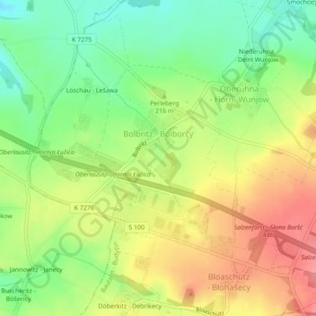
Name: Bolbritz topographic map, elevation, terrain.

Location: Bolbritz, Bautzen, Sachsen, Deutschland (51.19174 14.32407 51.20716 14.35213)

Average elevation: 213 m

Minimum elevation: 173 m

Maximum elevation: 254 m

Other topographic maps

Click on a map to view its topography, its elevation and its terrain.

Oehna

Deutschland > Sachsen > Bautzen > Bautzen > Teichnitz

Average elevation: 185 m

Schmole

Deutschland > Sachsen > Bautzen > Bautzen

Average elevation: 212 m

Gear up for your next adventure:

💡Compact LED Flashlight - Powerful and portable flashlight for outdoor use
🥾Approach Boots - Comfortable boots for hiking and climbing approaches
🥾Light Trekking Boots - Supportive boots for multi-day treks
🌬️Windproof Camp Stove - Efficient cooking even on exposed mountain peaks
🥾Waterproof Hiking Boots - Boots keeping your feet dry in wet conditions

As an Amazon Associate, this site earns from qualifying purchases at no extra cost to you.