
Thank you for supporting this site ❤️
Make a donation
Make a donation
Gear up for your next adventure:
As an Amazon Associate, this site earns from qualifying purchases at no extra cost to you.
Sankri topographic map
Click on the map to display elevation.
Thank you for supporting this site ❤️
Make a donation
Make a donation
Gear up for your next adventure:
As an Amazon Associate, this site earns from qualifying purchases at no extra cost to you.
About this map
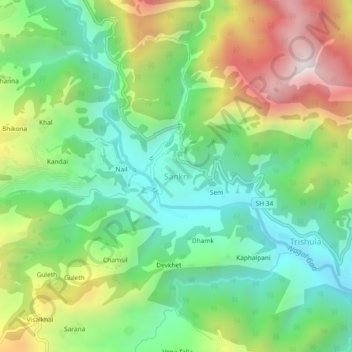
Name: Sankri topographic map, elevation, terrain.
Location: Sankri, Pokhari, Chamoli district, Uttarakhand, India (30.33786 79.21570 30.37786 79.25570)
Average elevation: 1,439 m
Minimum elevation: 1,034 m
Maximum elevation: 2,145 m
Thank you for supporting this site ❤️
Make a donation
Make a donation
Gear up for your next adventure:
As an Amazon Associate, this site earns from qualifying purchases at no extra cost to you.