
Thank you for supporting this site ❤️
Make a donation
Make a donation
Gear up for your next adventure:
As an Amazon Associate, this site earns from qualifying purchases at no extra cost to you.
Hospental topographic map
Click on the map to display elevation.
Thank you for supporting this site ❤️
Make a donation
Make a donation
Gear up for your next adventure:
As an Amazon Associate, this site earns from qualifying purchases at no extra cost to you.
About this map
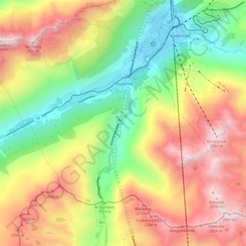
Name: Hospental topographic map, elevation, terrain.
Location: Hospental, Korporation Ursern, Uri, 6493, Switzerland (46.57341 8.50185 46.63943 8.61493)
Average elevation: 2,144 m
Minimum elevation: 1,430 m
Maximum elevation: 2,982 m
Thank you for supporting this site ❤️
Make a donation
Make a donation
Gear up for your next adventure:
As an Amazon Associate, this site earns from qualifying purchases at no extra cost to you.