Geolocate

Oudewater topographic map

Click on the map to display elevation.

About this map

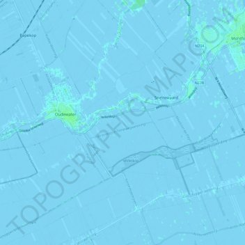
Name: Oudewater topographic map, elevation, terrain.

Location: Oudewater, Utrecht, Netherlands (51.98614 4.80670 52.05417 4.92004)

Average elevation: -1 m

Minimum elevation: -5 m

Maximum elevation: 4 m

Gear up for your next adventure:

💡LED Headlamp - Hands-free illumination for night hiking and camping
🔭Compact Monocular - One-handed bird watching and trail spotting
🧢Beanie Hat - Keep your head warm in cold weather
🩹Moleskin Blister Pads - Direct protection for painful foot pressure points
🧥Waterproof Pants - Keep dry during rainy hiking conditions

As an Amazon Associate, this site earns from qualifying purchases at no extra cost to you.