Geolocate

Banaba Cerca topographic map

Click on the map to display elevation.

About this map

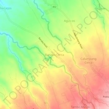
Name: Banaba Cerca topographic map, elevation, terrain.

Location: Banaba Cerca, Indang, Cavite, Calabarzon, 4122, Philippines (14.19454 120.83293 14.23454 120.87293)

Average elevation: 217 m

Minimum elevation: 132 m

Maximum elevation: 291 m

Other topographic maps

Click on a map to view its topography, its elevation and its terrain.

Bancod

Philippines > Cavite > Indang

Average elevation: 241 m

Kaytapos

Philippines > Cavite > Indang

Average elevation: 308 m

Banaba Cerca

Philippines > Cavite > Indang

Average elevation: 222 m

Buna Cerca

Philippines > Cavite > Indang

Average elevation: 333 m

Banaba Cerca

Philippines > Cavite > Indang

Average elevation: 222 m

Kaytapos

Philippines > Cavite > Indang

Average elevation: 308 m

Gear up for your next adventure:

💡LED Camping Lantern - Illuminate your campsite with long-lasting lanterns
🥾Trail Hiking Boots - Supportive boots for rough trails
Camping Tent - Weather-resistant tents suitable for 2 to 6 people
Camping Coffee Maker - Brew fresh coffee anywhere on the topographic map
🕶️Polarized Sunglasses - Reduces glare from snow and water at high elevations

As an Amazon Associate, this site earns from qualifying purchases at no extra cost to you.