
Make a donation
Gear up for your next adventure:
As an Amazon Associate, this site earns from qualifying purchases at no extra cost to you.
Portola Valley topographic map
Click on the map to display elevation.
Make a donation
Gear up for your next adventure:
As an Amazon Associate, this site earns from qualifying purchases at no extra cost to you.
About this map
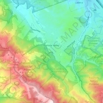
Name: Portola Valley topographic map, elevation, terrain.
Average elevation: 287 m
Minimum elevation: 78 m
Maximum elevation: 661 m
Make a donation
Gear up for your next adventure:
As an Amazon Associate, this site earns from qualifying purchases at no extra cost to you.
Other topographic maps
Click on a map to view its topography, its elevation and its terrain.
Portola Highlands Park
United States > California > San Mateo County > San Bruno
Average elevation: 182 m
Make a donation
Gear up for your next adventure:
As an Amazon Associate, this site earns from qualifying purchases at no extra cost to you.
Baden
United States > California > San Mateo County > South San Francisco > Baden
Average elevation: 50 m
San Carlos
United States > California > San Mateo County > San Carlos > San Carlos
Average elevation: 47 m
Half Moon Bay
United States > California > San Mateo County > Half Moon Bay > Half Moon Bay
Average elevation: 73 m
Make a donation
Gear up for your next adventure:
As an Amazon Associate, this site earns from qualifying purchases at no extra cost to you.