
Make a donation
Gear up for your next adventure:
As an Amazon Associate, this site earns from qualifying purchases at no extra cost to you.
Valdazze topographic map
Click on the map to display elevation.
Make a donation
Gear up for your next adventure:
As an Amazon Associate, this site earns from qualifying purchases at no extra cost to you.
About this map
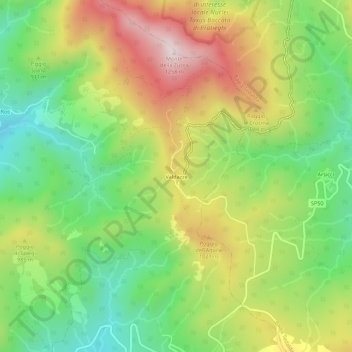
Name: Valdazze topographic map, elevation, terrain.
Location: Valdazze, Pieve Santo Stefano, Arezzo, Toscana, 52036, Italia (43.69303 12.06748 43.73303 12.10748)
Average elevation: 886 m
Minimum elevation: 617 m
Maximum elevation: 1,244 m
Make a donation
Gear up for your next adventure:
As an Amazon Associate, this site earns from qualifying purchases at no extra cost to you.
Other topographic maps
Click on a map to view its topography, its elevation and its terrain.
Riserva naturale dell'Alta Valle del Tevere - Monte Nero
Italia > Toscana > Arezzo > Pieve Santo Stefano
Average elevation: 965 m
Make a donation
Gear up for your next adventure:
As an Amazon Associate, this site earns from qualifying purchases at no extra cost to you.